Record sea surface temperatures in the Pacific and above average waters in the South Caribbean supercharged the passing atmospheric river that fed this classic El Niño storm
A “remarkably rare” storm of “unprecedented strength” dumped record amounts of rain in the south central US beginning Monday, March 7, and forecasters expect the deluge to continue through Saturday. Northern Louisiana has seen the worst impacts so far, with widespread 1-in-200 year rainfall with locations experiencing 1-in-1,000 year rains.
Climate connections of the Mayan Express
This El Niño/Mayan Express storm:
Is supercharged by running through an atmosphere made wetter by climate change.
Is fueled by SST temps running hot due to El Nino, but bumped up even higher by global warming, both over the eastern pacific and the Southern Caribbean.
May have also been fueled directly by global warming which is tentatively expected to make intense El Nino’s more common.
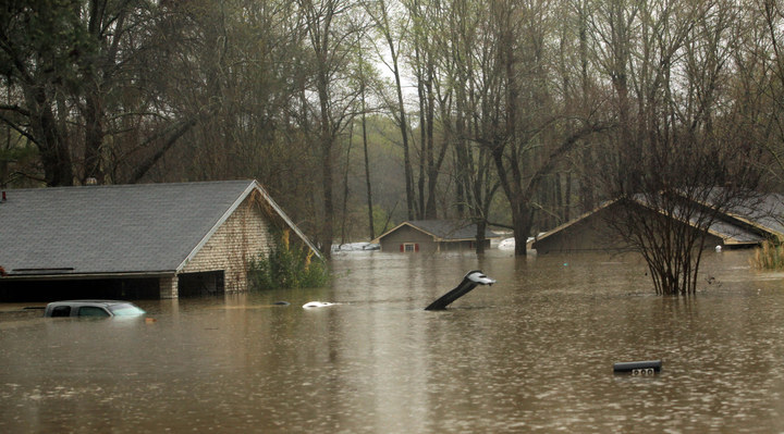
Image 1: This tree of climate signals is schematic only. It illustrates factors that link individual events to climate change. The diagram does not quantify the relative strength of each factor, nor does it illustrate the natural factors that often shape extreme events, including natural variability and regular circulation changes. Dashed lines indicate science with tentative connections.
Image 2: Elevated sea surface temperatures in the southern Carribbean fed the Mayan Express with extra moisture.
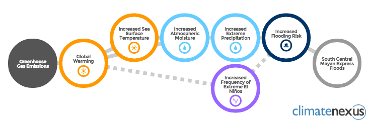
Image 3: Seventy-two hour rainfall totals show regions receiving up to 20 inches of water.
Quotes
Kevin Trenberth:
“The moisture for the storms comes through the Gulf but most originates in tropical and subtropical North Atlantic 1000 to 1500 miles away, where SSTs are above normal. Classic spring time situation. Generally the southern North Atlantic warms up in latter stages of El Nino, a consequence of the action in the Pacific making for more settled weather, sunny skies and lighter winds (less evaporative cooling) and thus higher SSTs.”
Jeff Masters:
“An atmospheric river has set up providing a direct pipeline to moisture over the Eastern Pacific over the waters where El Nino has warmed the waters by 2 degree C.”
“upper-level low pressure system of unprecedented strength in the historical record” for the Southern US and mountains of Mexico
“upper low tapped into an atmospheric river of moisture from both the Western Caribbean and the Eastern Pacific”
“upper low originated from energy that moved across southern California late in the weekend, producing heavy thunderstorms. Rather than barreling across the southeast U.S., the powerful subtropical jet stream carved out a progressively deeper trough into Mexico that cut off from the jet stream, forming a slow-moving closed low”
“Sea Surface Temperatures (SSTs) are near average over the Gulf of Mexico, which will keep the amount of moisture available to this week’s storms lower than would be the case if SSTs were unusually warm. However, the cut-off low has tapped into a moisture source in the deep tropics over the Eastern Pacific where Clim SSTs are record warm.”
“An ‘atmospheric river’ of water vapor can be seen on satellite images extending from the record-warm waters south of Mexico directly into the Southern U.S. This warm, moist air will be very unstable, helping contribute to severe thunderstorms with a few tornadoes over the Southern U.S. today through Thursday.”