U.S. temperature extremes in 2014 have been exceptional—with record heat in the West and cooler than average temperatures in the East—and many scientists think climate change may be contributing. Temperature extremes occur when regions experience temperatures at the top or bottom 10% of the historical range of recorded values. In most years since the U.S. temperature record began in 1895, nationwide temperature extremes have been either warmer or cooler on average compared to the historical record (with the overall trend being towards fewer cold extremes). However, 2014 has witnessed a record setting split between regions of simultaneous hot and cool temperatures (as shown in the NOAA graphic below).
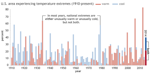
From January to July, 21.1% of the country experienced extreme warmth and 18.9% experienced extreme coolness, for a combined 40% of the country affected by extremes. The radically oppositional nature of this year’s extremes make them all the more unusual.
The extreme temperatures we’ve seen this year are consistent with the positive phase of an atmospheric phenomenon called the Pacific-North American teleconnection pattern (PNA). The PNA is one of the most recognized and influential climate patterns in the Northern Hemisphere mid-latitudes. It is tied to fluctuations in the strength and location of the polar jet stream—a band of wind in the upper atmosphere that affects weather down below. When the PNA is in its “positive phase,” the jet stream shifts southeastward so that cool air in Canada plunges towards the U.S. and exits in the east. As a result, the eastern U.S. experiences below normal temperatures, and the western U.S. experiences above normal temperatures.
While this climate pattern is well known, there is a growing body of scientific evidence suggesting that climate change may be contributing to the pattern’s unusual strength and persistence. It is, however, a very new area of research. The following roundup shows what scientists have been working on recently, uncovering the details of just how warming could be influencing the weather pattern which gave us an unusual year of extremes.
Faster Warming in the Arctic
Jennifer Francis has theorized that recent weather extremes in the Northern mid-latitudes may be due to warming in the Arctic, which has occurred at a rate more than twice as fast as the global average (a phenomenon known as “Arctic amplification”). According to her research, Arctic warming causes jet streams to weaken and to have larger north-south waves. When these waves get larger, they move more slowly, which can cause weather systems to also move more slowly and even become stuck in place. This in turn increases the likelihood of disasters caused by persistent weather conditions, including droughts, heat waves, floods, long cold spells, and heavy snows.
Similarly, a team of international scientists led by Zhongfang Liu recently published a study researching the history of the jet stream pattern in North America. Based on what happened in past millennia, their research suggests that reduced equator-to-pole temperature differences due to climate change may enhance jet stream patterns that bring weather extremes.
A team of researchers led by Judah Cohen recently summarized the possible pathways by which Arctic amplification may lead to more frequent extreme weather events across the Northern Hemisphere mid-latitudes—including the jet stream, changes in storm track, and planetary waves—but they ultimately argue more research is necessary.
Heat Exchange with the Ocean
Kevin Trenberth and his research team tie the unusual atmospheric patterns to increased heat storage in the deep oceans and decadal trends in the Pacific Ocean—known as the Pacific Decadal Oscillation (PDO). Their research connects the Pacific Ocean’s influence on the atmosphere to many of the regional atmospheric anomalies we’ve seen across the U.S. and in Europe.
Similarly, Tim Palmer, a research professor in climate physics at Oxford, speculates that increased greenhouse gases may have influenced sea surface temperatures, helping to trigger the large north-south jet stream waves leading to this year’s extreme hot and cold temperatures in the U.S.
Much of the science is quite new, and scientists acknowledge that much more research is needed before we can fully understand the relationship between global warming, the PNA, jet stream, and extreme weather. That said, the research done thus far points toward a more complete picture of how global warming has already changed our climate and what we might expect in the future.